

| One China One 1中1 1中1: Greater China 大中國 大中国: Past, Present, Future 過往 今日 明天 过往 今日 明天: 001 |

| One China One: 001: China Geography 中國地理 中国地理 aaf: Geography of Hong Kong from Wikipedia, the free encyclopedia |
| |
| |
| |
| |
| |
| |
| |
| |
| |
| |
| |
| |
| |
| |
| |
| |
| |
| |
| |
| |
| |
| |
| |

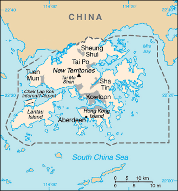
The geography of Hong Kong primarily consists of three main territories: Hong Kong Island, Kowloon Peninsula,
and the New Territories. The geography of Hong Kong is varied and is home to various physical geographical
features.
The name "Hong Kong", literally meaning "fragrant harbour", is derived from the area around present-day
Aberdeen on Hong Kong Island, where fragrant wood products and fragrant incense were once traded[1]. The
narrow body of water separating Hong Kong Island and Kowloon Peninsula, Victoria Harbour, is one of the
deepest natural maritime ports in the world.
Overview
Hong Kong and its 260 territorial islands and peninsulas are located in the South China Sea, at the mouth of the
Pearl River Delta.
The Kowloon Peninsula to the south of Boundary Street and the New Territories to the north of Hong Kong Island
were added to Colonial Hong Kong in 1860 and 1898 respectively. The body of water between Hong Kong Island
and Kowloon Peninsula is Victoria Harbour, one of the deepest maritime ports in the world. The landscape of
Hong Kong is fairly hilly to mountainous with steep slopes. The highest point in the territory is Tai Mo Shan, at a
height of 958 metres[2]. Lowlands exist in the northwestern part of the New Territories.
Hong Kong is 60 km east of Macau on the opposite side of the Pearl River estuary. It has a land border with
Shenzhen to the north. Of the territory's 1,092 square kilometres, less than 25 percent is developed.[citation
needed] The remaining land is reserved as country parks and nature reserves.
Geographical information

Districts of the Hong Kong
Special Administrative
Region: 1. Islands; 2. Kwai
Tsing; 3. North; 4. Sai
Kung; 5. Sha Tin; 6. Tai Po;
7. Tsuen Wan; 8. Tuen
Mun; 9. Yuen Long; 10.
Kowloon City; 11. Kwun
Tong; 12. Sham Shui Po;
13. Wong Tai Sin; 14. Yau
Tsim Mong; 15. Central
and Western; 16. Eastern;
17. Southern; 18. Wan Chai
Special Administrative
Region: 1. Islands; 2. Kwai
Tsing; 3. North; 4. Sai
Kung; 5. Sha Tin; 6. Tai Po;
7. Tsuen Wan; 8. Tuen
Mun; 9. Yuen Long; 10.
Kowloon City; 11. Kwun
Tong; 12. Sham Shui Po;
13. Wong Tai Sin; 14. Yau
Tsim Mong; 15. Central
and Western; 16. Eastern;
17. Southern; 18. Wan Chai

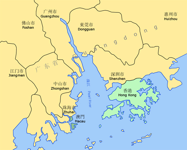
| Location of Hong Kong with respect to the Pearl River Delta |
| Hong Kong borders the city of Shenzhen in Guangdong Province (which is not labeled on this map). The map also shows Hong Kong's maritime boundaries. |
| Map showing Hong Kong and surrounding cities |
Location
facing the East China Sea.
facing the East China Sea.
Area
Total: 1,092 km²
Land: 1,042 km²
Water: 50 km²
Figures published by the United States Central
Intelligence Agency[2].
Land boundaries
Hong Kong borders the city of Shenzhen in Guangdong
Province (which is not labeled on this map). The map
also shows Hong Kong's maritime boundaries.Total: 30
km
Border city: Shenzhen Special Economic Zone,
Guangdong Province
Figures published by the United States Central
Intelligence Agency[2]
Coastline
Total: 733 km
Maritime claims:
Territorial sea: 3 nm
Figures published by the United States Central
Intelligence Agency[2]
facing the East China Sea.
facing the East China Sea.
Area
Total: 1,092 km²
Land: 1,042 km²
Water: 50 km²
Figures published by the United States Central
Intelligence Agency[2].
Land boundaries
Hong Kong borders the city of Shenzhen in Guangdong
Province (which is not labeled on this map). The map
also shows Hong Kong's maritime boundaries.Total: 30
km
Border city: Shenzhen Special Economic Zone,
Guangdong Province
Figures published by the United States Central
Intelligence Agency[2]
Coastline
Total: 733 km
Maritime claims:
Territorial sea: 3 nm
Figures published by the United States Central
Intelligence Agency[2]
Natural resources
The natural resources of Hong Kong can be divided into three main categories:
Metalliferous minerals and non-metalliferous industrial minerals in the onshore area;
Quarried rock and building stone;
Offshore sand deposits.
have been commercially exploited include kaolin clay, feldspar, quartz, beryl and graphite.[6]
have been commercially exploited include kaolin clay, feldspar, quartz, beryl and graphite.[6]
For many years, granite and volcanic rocks have been quarried locally for road base metal, pell mell, armour stone and asphalt, although the main purpose now is for concrete aggregates. At present,
there are three quarries operating in Hong Kong. These are principally in granite and are located at Lam Tei, Shek O and Anderson Road. All the quarries are in the process of rehabilitation and have a
life expectancy of between two to eight years.[6]
Offshore sand bodies have been dredged for aggregate sand and reclamation fill in Hong Kong has grown as the rate of urban development has increased.[7]
Land use
Arable land: 5.05%
Permanent crops: 1.01%
Other: 93.94% (2001 est.)
Figures published by the United States Central Intelligence Agency[2]
Natural hazards
Tropical cyclones frequent Hong Kong during the summer months between June and August typically. Landslides are common after a rainstorm.
Environmental issues
Air and water pollution from rapid urbanisation
Extinction of natural species
Introduction of exotic species
See also: Ecology of Hong Kong
See also
Hong Kong portal
Country parks and conservation in Hong Kong
Beaches of Hong Kong
Rivers of Hong Kong
List of bays in Hong Kong
List of areas of Hong Kong
Geography of China
Geology of Hong Kong
References
^ Visit Hong Kong: Volume 1, Spring, 2004 (p.14), University of Hong Kong English Centre.
^ a b c d e f The World Factbook, Central Intelligence Agency, United States. Last updated 23-01-2007.
^ Travelling to Hong Kong - Travel Health Service, HKSAR. Retrieved on 16 February 2007.
^ Hong Kong Survey & Mapping Office, Lands Department. Hong Kong Guide 2007 [map]. Notes on Hong Kong, p. 411. ISBN 962-567-174-9.
^ Climate of Hong Kong Hong Kong Observatory. Retrieved on 1 Sep 2007.
^ a b R.J. Sewell, S.D.G. Campbell, C.J.N. Fletcher, K.W. Lai & P.A. Kirk (2000). The Pre-Quaternary Geology of Hong Kong. Government of Hong Kong SAR. ISBN 9620202996.
^ J.A. Fyfe, R.Shaw, S.D.G. Campbell, K.W. Lai & P.A. Kirk (2000). The Quaternary Geology of Hong Kong. Government of Hong Kong SAR. ISBN 9620202988.
External links
Climate of Hong Kong
The Lands Department of the Governement of Hong Kong
Waterfalls in Hong Kong
"Hong Kong in Figures 2006 Edition", Census and Statistics Department, HKSAR. February 2006.
Islands
Hong Kong has 262 islands[3] including Hong Kong Island, Lantau Island, Cheung
Chau, Lamma Island, Peng Chau and Tsing Yi Island.
Climate
Main article: Climate of Hong Kong
cyclones between May and November, most often from July to September. The
cyclones between May and November, most often from July to September. The
mean temperature of Hong Kong ranges from 17 °C in January to 29 °C in July.[4]
mean temperature of Hong Kong ranges from 17 °C in January to 29 °C in July.[4]
New Territories. March and April can be pleasant although there are occasional
New Territories. March and April can be pleasant although there are occasional
spells of high humidity. Fog and drizzle are common on high ground which is
exposed to the southeast. May to August are hot and humid with occasional
showers and thunderstorms. Afternoon temperatures often exceed 31 °C whereas
at night, temperatures generally remain around 26 °C with high humidity. In
November and December there are pleasant breezes, plenty of sunshine and
comfortable temperatures.[5]
comfortable temperatures.[5]
Terrain
Hong Kong's terrain is hilly and mountainous with steep slopes. There are
lowlands in the northern part of Hong Kong. A significant amount of land in Hong
Kong, especially on the Hong Kong Island and the Kowloon peninsula, is reclaimed.
Extreme points
The lowest elevation in Hong Kong is in South China Sea (0 m) while the highest
elevation is at Tai Mo Shan (958 m) in Tsuen Wan, the New Territories.
Northernmost: Shenzhen River
Easternmost: Ping Chau
Southernmost: Po Toi Island
Westernmost: Fan Lau
Figures published by the United States Central Intelligence Agency[2]
Principal peaks of Hong Kong
Map showing Hong Kong and surrounding citiesMain article: List of mountains,
peaks and hills in Hong Kong
Tai Mo Shan - 958 m, Tsuen Wan
Lantau Peak (Fung Wong Shan) - 934 m, on Lantau Island
Sunset Peak (Tai Tung Shan) - 869 m, on Lantau Island
Sze Fong Shan - 785 m
Lin Fa Shan - 766 m, on Lantau Island
Nei Lak Shan - 751 m, on Lantau Island
Yi Tung Shan - 747 m, on Lantau Island
Ma On Shan - 702 m
The Hunch Backs (Ngau Ngak Shan) - 674 m
Grassy Hill - 647 m
Wong Leng - 639 m
Buffalo Hill - 606 m
West Buffalo Hill - 604 m
Kowloon Peak (Fei Ngo Shan) - 602 m
Shun Yeung Fung - 591 m
Tiu Shau Ngam - 588 m
Kai Kung Leng - 585 m
Castle Peak - 583 m
Lin Fa Shan, Tsuen Wan - 578 m
Tate's Cairn (Tai Lo Shan) - 577 m
Victoria Peak, the highest point on Hong Kong Island, at 552 m is the 24th highest
peak in Hong Kong.


| | | | | | |